Facts About The Catawba River Basin In North Carolina
The Catawba River basin is located in the southwestern part of the state of North Carolina. According to North Carolina State University, it takes up 3,305 square miles, or about 8.1 percent of the state, and is the eighth largest river system in North Carolina. In fact, it contains more than 3,000 miles of streams. The historically important river continues to make history in modern society.
History
History
The Catawba River basin has served a significant role in the North Carolina region's history from pre-colonial times to the present, according to the Catawba Riverkeeper Foundation. Nation Ford was an important river crossing on a major north-south trading path that the Catawba Indians controlled. A canal system in the 19th century made the Catawba River navigable, and dams along the Catawba-Wateree River in the 20th century offered the energy and water that area industries and a growing population required. The basin remains one of the fastest growing regions of the United States.
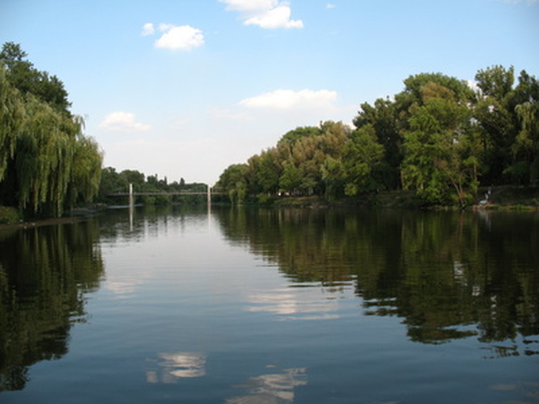
Uses
Uses
The Catawba River begins on the eastern slopes of the Blue Ridge Mountains, according to the North Carolina Office of Environmental Education. The river's headwaters start in the mountains and are considered trout waters that generally have good quality. A headwater stream known as the Linville River actually is one of only four rivers in North Carolina that the General Assembly has labeled a scenic river. The stream's main channel also is enveloped by multiple hydropower reservoirs that begin at Lake James and go to Lake Wylie. Lake James is in the mountains, and Lake Wylie is near the North Carolina-South Carolina border. These reservoirs are water resources and also are used for recreational purposes. In fact, Lake Wylie has been named a South Carolina scenic river as well. The Catawba River contains the most major dams of any North Carolina river.
Population
Population
The Catawba River basin actually takes up part or all of 14 counties. These counties include Wilkes, Alexander, Watauga, Avery, Union, Burke, Mecklenburg, Caldwell, McDowell, Catawba, Lincoln, Cleveland, Iredell and Gaston. In fact, the river basin is the second most densely populated region in the state, as more than one million people reside there. Charlotte, the largest municipality in the state, contains more than half of the basin's population.
Quality Issues
Quality Issues
About 16 percent of the Catawba River basin actually is polluted by bad runoff, according to North Carolina State University Water Quality Programs. This runoff in downstream areas arrives from construction, stormwater and agricultural and timbering activities. The main cause of the problem is sediment, but the problem also can be linked to heavy metals, fecal coliform and nutrients from urban areas and wastewater treatment plants. This is especially troubling as an expanding population relies on the river and as drought has resulted in water shortages. In fact, the environmental group American Rivers in 2008 named the Catawba-Wateree River the most endangered river in the nation.
In 2009, the U.S. Environmental Protection Agency announced that four of the 44 highest hazard coal ash ponds in the nation were on the Catawba River on reservoirs used for drinking water. Citizens have created organizations such as the Catawba Riverkeeper Foundation to address these issues. Projects being conducted in the Catawba River basin include monitoring water quality from agricultural acts and establishing practices to protect the water.
Animals
Animals
The Catawba River basins contains many distinctive animals such as a globally rare dragonfly called Edmund's snaketail. The basin also contains the federally endangered Carolina heelsplitter, a freshwater mussel. Like all of these types of mussels, the heelsplitter is sensitive to water quality changes.
Cite This Article
MLA
King, YaShekia. "Facts About The Catawba River Basin In North Carolina" sciencing.com, https://www.sciencing.com/catawba-river-basin-north-carolina-7230896/. 22 November 2019.
APA
King, YaShekia. (2019, November 22). Facts About The Catawba River Basin In North Carolina. sciencing.com. Retrieved from https://www.sciencing.com/catawba-river-basin-north-carolina-7230896/
Chicago
King, YaShekia. Facts About The Catawba River Basin In North Carolina last modified March 24, 2022. https://www.sciencing.com/catawba-river-basin-north-carolina-7230896/