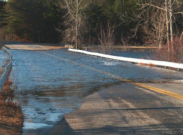
Weather forecasting technology has allowed meteorologists to provide people with short-term forecasts. Unfortunately, simply predicting a thunderstorm doesn't necessarily mean knowing the amount of rainfall it'll produce. Because of this, hundreds of individuals die every year due to flooding. Luckily, technological advancement has allowed us to focus on finding better tools used to predict a storm's intensity.
Rain Gauges
A rather simple device, the rain gauge acts like a measuring cup to measure the amount of precipitation in a certain area. Using a rain gauge allows meteorologists to know exactly how much rain has fallen, allowing them to gauge exactly how much moisture is within the soil. Rain gauges aren't the best tool for predicting floods; in fact, they are only helpful to predict floods within the area where the rain gauge is situated. The local weather services may report 2 inches rainfall where the gauge was located, but since the amount of rainfall varies from neighborhood to neighborhood, the information is not exactly accurate.
Airborne Lasers
In the Queenstown Lakes district in New Zealand, meteorologists are scanning targeted areas with lasers in order to predict flash floods. The LiDAR (Light Detection and Ranging) laser scanner is secured to an aircraft. As the aircraft flies over, the laser gathers information about the area below including changes in the shoreline. The U.S. National Oceanic and Atmospheric Administration and NASA are using the data to determine these changes and predict possible flooding.
Satellites
On November 2, 2009, the European Space Agency launched the Soil Moisture and Salinity (SMOS) satellite. It measures moisture levels of the soil, rate of plant growth and salt levels in the ocean over the entire planet. It sends the gathered measurements back to Earth where scientists use the data to predict possible flooding or extreme dry conditions. NASA is also using the Tropical Rainfall Measuring Mission (TRMM) to measure the amount of moisture within the Earth's soil. The satellite detects changes in microwave radiation being emitted by the ground. When the ground is dry, it is warm, therefore more microwaves are emitted. When the ground is wet, it is cooler, so less microwaves are emitted. Because the ground soaks up less moisture when it is saturated (like a sponge), it is likely that a flood could occur in areas where the ground is significantly moistened, as the soil cannot absorb any more water.
References
Resources
About the Author
Since 2007, Emilia Lamberto has been a professional writer specializing in home and garden, beauty, interior decorating and personal relationships. Her work has appeared in various online publications. Lamberto owns two blogs, one which provides readers with freelance job opportunities and one which covers beauty advice and product reviews.
Photo Credits
flood image by brelsbil from Fotolia.com