From towering peaks to deep basins, the southwestern region of the United States is home to a colorful assortment of distinctive landforms. The exact conclusion on which land areas constitute the southwestern region differs depending on the source, but it always includes the states of New Mexico and Arizona. Definitions of the Southwest may also include all or parts of California, Nevada, Utah, Colorado, Texas and even Oklahoma.
Mountain Ranges
The Rocky Mountains are an immense 3,000-mile chain extending through the western U.S. and Canada, and their southern portion covers segments of New Mexico, Utah and Colorado. In fact, the highest point in the entire chain is Colorado’s Mt. Elbert, which rises to 4,399 meters (14,433 feet). Several subsidiary mountain ranges lie within the southern Rockies. Most notable are New Mexico’s Jemez Mountains; the San Juan and Sangre de Cristo Mountains, which run in parallel curves through southern Colorado and northern New Mexico; and central Colorado’s Front Range, which rises dramatically out of the flat terrain to its east. Other mountain ranges in the peripheral southwest states include California’s Sierra Nevada Mountains, Utah’s Wasatch Mountains and Texas’s Guadalupe Mountains.
Plateaus
The southwestern U.S. landscape also features plateaus: elevated surfaces with relatively level tops. Arguably the most significant plateau in the Southwest is the Colorado Plateau, which covers nearly 337,000 square kilometers (130,000 square miles) in Arizona, New Mexico, Colorado and Utah. As with the Rocky Mountains, smaller plateaus are contained within the Colorado Plateau. For instance, the Kaibab Plateau adjoins Arizona’s Grand Canyon and reaches a height of more than 2,804 meters (9,200 feet). The Paunsaugunt Plateau borders Utah’s Bryce Canyon National Park, and the Grand Staircase comprises a linked series of plateaus between the Grand Canyon and Bryce Canyon.
Plains and Basins
Although much of the Southwest sits at high elevation and contains lofty mountain peaks, the region has lower-lying and flatter zones as well. The Great Basin, a bowl-like expanse interrupted by series of valleys and mountains, usurps most of Nevada as well as portions of Utah and California. The Badwater Basin within California’s Death Valley is the lowest point in North America and lies within the Great Basin. On the opposite side of the region, the southern extent of the Great Plains -- America’s breadbasket -- covers much of Texas and Oklahoma, plus the eastern third of Colorado and New Mexico.
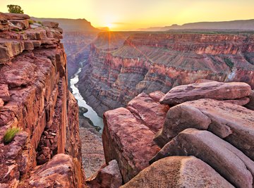
Canyons and Escarpments
The southwestern region’s most famed canyon, the Grand Canyon, stretches for 446 kilometers (277 miles) along the Colorado River in northwestern Arizona. This canyon, among the most significant geological features on the planet, plunges more than 1.7 kilometers (1 mile) deep in spots. The other two most prominent canyons in the Southwest are southern Utah’s Bryce Canyon and Zion Canyon, the latter of which is technically an escarpment, or steep slope, of Paunsaguant Plateau. One last major landform in the Southwest is Arizona’s Mogollon Rim, a 610 meter (2,000 foot) high escarpment that forms the southern edge of the Colorado Plateau.
References
About the Author
Based in western New York, Amy Harris began writing for Demand Media and Great Lakes Brewing News in 2010. Harris holds a Bachelor of Science in Mathematics from Penn State University; she taught high school math for several years and has also worked in the field of instructional design.