Rain Clouds Vs. Snow Clouds
Though clouds come in different formations, they are all made up of small particles of ice or water. While not all clouds precipitate, some types of clouds result in both rain and snow. Being able to tell the difference between cloud types helps you predict and prepare for the weather.
Rain cloud formation
Clouds are created from evaporated water that has risen through Earth's atmosphere. The water vapor then cools and condenses, changing back to a solid form from gas. To condense, water vapor needs to stick to a solid object in the sky, like an ice crystal or speck of pollen. The cloud forms as further water droplets condense and grow together. Though all clouds are made up of water particles, not all clouds result in rain.
As the water droplets condense, they become heavier. When they get too heavy, they fall through the atmosphere, resulting in rain, snow, or hail. Eventually, after the rain hits the ground, the water evaporates and the cycle repeats.
Snow cloud formation
For snow to fall from clouds instead of rain, air temperatures must be below 35.6 degrees Fahrenheit (2 degrees Celsius). Warmer temperatures will melt snow as it falls, creating rain. Dry, powdery snow forms when the air is cooler than 32 degrees Fahrenheit. Because of the dryness, the snowflakes don't stick together as they fall. When temperatures warm slightly, the outsides of snowflakes melt as they fall, sticking together creating large droplets of "wet" snow.
Hail forms when a falling ice crystal — which would become a snowflake if the air temperature was consistently cold enough between the cloud and the ground — hits warmer air, is caught in an updraft, and is sent back up into the atmosphere before it hits the ground. As the ice crystal or snowflake falls and encounters those warmer air temperatures, it melts slightly, and more water droplets stick to it.
Returning to the upper atmosphere refreezes the snowflake, making it bigger. This process can repeat until the hailstone is too big for the updrafts to push it back up, and it plummets to the ground. In 2010, the largest recorded hailstone fell in Vivian, South Dakota, with an 18.62-inch circumference and weighing 1.93 pounds.
Types of clouds
Types of clouds are grouped based on their height in the atmosphere above the ground and on their texture. High-level clouds are formed from ice crystals due to the low temperatures, and these clouds have a wispy appearance. Mid-level clouds are formed from either water droplets or ice crystals depending on the time of year, altitude, and the troposphere's vertical temperature structure. Most of the year, low-level clouds are formed from water droplets, except in winter, when they can be formed from ice crystals when temperatures are cool enough.
High-level rain clouds
Feathery cirrus clouds are the first signal to a front coming in and generally thicken to form cirrostratus clouds. Cirrostratus clouds are thin, high clouds located between 16,500 and 45,000 feet that cover the whole sky with hexagonal ice crystals, resulting in a halo effect appearing around the sun or moon. Seeing cirrostratus clouds indicates that it will likely rain or snow in the next 24 hours. Oftentimes, cirrostratus clouds thicken, producing altostratus, stratus, or nimbostratus rain or snow clouds.
Mid-level rain cloud formations
Altostratus mid-level clouds are located between 6,500 and 23,000 feet. This type of cloud covers the entire sky and is flat and even. Altostratus clouds are often gray or blue-gray in color, and the sun or moon's light may peek through as a small dot. These clouds are predictors for rain but don't produce rain or snow themselves; instead, they thicken to form nimbostratus rain or snow clouds. If altostratus clouds become dense enough, rain may fall, but it will come in sprinkles or light showers.
Low-level cloud formations
Low-level clouds are lower than 6,500 feet in the sky. Like altostratus, vertically forming nimbostratus clouds create a uniform blanket across the sky. Nimbostratus clouds are dark gray clouds that are so thick they block out the sun or moon completely, blending into the falling rain or snow.
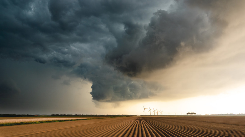
Stratus clouds are thin blankets of clouds that form horizontally with a foggy appearance covering mountains or hills. While they look ominous, they are so thin that, if anything, they will only produce a light drizzle. On the other hand, cumulonimbus clouds predict thunderstorms, heavy rain, hail, or tornadoes on hot days. These clouds look like grand mountains or towers from a distance.