The One Area On Earth's Surface That Has The Weakest Gravitational Pull
We are fascinated by the gravitational differences between other planets, but rarely do we recognize the gravitational variations upon our own. If Earth was a perfectly smooth sphere of equal density throughout, the force of gravity would be the same all around the globe, but that's not how it really works. Earth is not a perfect sphere — its rotation makes it bulge around the equator — nor is its surface smooth or its interior uniform. Variations in mass and density around Earth's surface lead to variations in the planet's gravitational field, including one particularly extreme example.
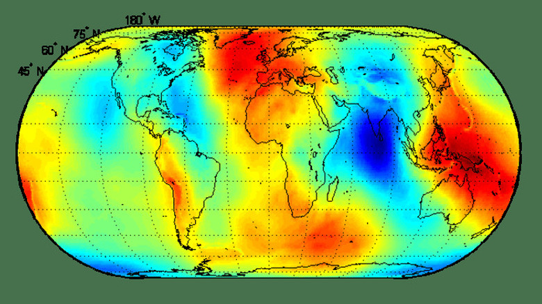
About 700 miles off the southern tip of India, there is a 1.2 million-square-mile patch of the ocean where you'll find the weakest gravitational pull on the planet. Known as the Indian Ocean gravity hole, or geoid low, it was first discovered in 1948 by Dutch geophysicist Felix Andries Vening Meinesz, who developed one of the earliest gravimeters for underwater surveys. It has been baffling scientists around the world ever since.
One of the most noticeable effects of variations in Earth's gravitational field is on sea levels. Water is drawn to the spots where gravity is strongest, creating sea levels higher than average, while areas with lower gravity have lower sea levels. Gravity at the Indian Ocean geoid low is so weak that the sea level is 348 feet below average. For decades, geophysicists have puzzled over how this extreme zone formed, but only in this decade has a potential answer emerged.
Scientists think they've discovered how the Indian Ocean gravity hole formed
In May, 2023, researchers from the Indian Institute of Science published a paper in Geophysical Research Letters which proposed that the Indian Ocean geoid low was formed through the destruction of an ancient ocean. During the Jurassic period, the supercontinent of Pangea began to break apart, splitting into two continents known as Gondwana, which comprised the global south, and Laurasia, which comprised the global north. These continents were separated by a body of tropical saltwater known as the Tethys Ocean, or Tethys Sea.
The research team used a series of computer models to trace tectonic activity back to the time when Gondwana began to break apart. The portion of Earth's crust that lay beneath the Tethys Ocean was subducted beneath the Eurasian plate, pushing pieces of the planet's crust deep beneath the surface. According to the models, these descending fragments dislodged a chunk of crystalized magma within Earth's mantle, which then became trapped beneath the African continent. The magma that flowed into its place was much less dense than the crystalized magma, making that portion of the mantle less dense, and therefore weaker in gravity.
Further research is needed to verify these findings, but this might have solved one of geophysics' greatest mysteries. It's likely that the geoid low won't be around forever, as tectonics are constantly shifting. Earth is already forming a sixth ocean, which will break Africa apart, causing new imbalances in Earth's surface, and potentially, its gravity.

