What Is In The Outer Band Of A Hurricane?
Every June, people in the North Atlantic prepare for hurricane season, a six-month period during which powerful tropical storms can develop and wreak havoc on coastal communities. Hurricanes begin as tropical depressions in the warm waters near the equator, and they can, if conditions are right, pack winds of more than 160 kilometers per hour (more than 100 mph). The outer band of a hurricane consists of rain clouds that can be as beautiful as they are threatening.
Hurricane Development
Hurricane Development
Hurricanes are not unique to the North Atlantic — in the North Pacific, people call them typhoons, and in the Southern Hemisphere, they are simply known as tropical cyclones. They begin as a series of disorganized thunderstorms over tropical ocean waters that are at least 46 meters (150 feet) deep and at a temperature of at least 27 degrees Celsius (80 degrees Fahrenheit). A third ingredient for hurricane development is light winds in the upper atmosphere. These conditions allow warm air to begin to rise, drawing moisture with it. The moisture cools as it rises and eventually falls as rain.
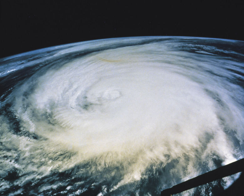
The Gathering Storm
The Gathering Storm
As the air rises, cools and falls again, it releases energy that causes the thunderstorm clouds to start swirling around an area of low air pressure. This swirling motion becomes more intense as air rises higher into the upper atmosphere, and when it reaches 120 kilometers per hour (74 miles per hour), a hurricane is born. At this point it has a well-developed eye — an area of calm at the center — surrounded by a vortex of high winds and heavy rain, called the eyewall. Large spirals of swirling clouds form around the eyewall and extend away from it for hundreds of miles.
The Rainbands
The Rainbands
As a hurricane approaches, the outer edges of the rainbands herald its arrival. In the United States, hurricanes come from the south, and because hurricanes rotate counterclockwise in the Northern Hemisphere, the leading edge of clouds come on easterly winds. After the hurricane has passed, the winds are from the west. The very first clouds to appear are high, billowy cumulus clouds, but as the hurricane gets closer, they turn into bands that move more and more quickly. As the intensity of the storm increases, more rain begins falling because rainfall is what is fueling it.
The Right Side is Stronger
The Right Side is Stronger
A hurricane follows a complex route that depends on atmospheric conditions in its path, and in general, the right side of the hurricane, as determined by someone looking at it from behind, has the highest winds. A hurricane moving north through the southern United States, therefore, causes more destruction in states to the east of its travel. Although the fiercest winds are in the eyewall near the center of the storm, gale-force winds can occur as far as 480 kilometers (300 miles) from there. They fall off from there toward the leading and tailing edges of the storm.
Cite This Article
MLA
Deziel, Chris. "What Is In The Outer Band Of A Hurricane?" sciencing.com, https://www.sciencing.com/outer-band-hurricane-23920/. 25 August 2017.
APA
Deziel, Chris. (2017, August 25). What Is In The Outer Band Of A Hurricane?. sciencing.com. Retrieved from https://www.sciencing.com/outer-band-hurricane-23920/
Chicago
Deziel, Chris. What Is In The Outer Band Of A Hurricane? last modified March 24, 2022. https://www.sciencing.com/outer-band-hurricane-23920/