Stages Of A Tropical Cyclone
All types of tropical storms form in the same way, starting with a tropical disturbance. Wind speed then determines whether a thunderstorm develops into a depression, storm or cyclone. When tropical cyclones reach land, giant waves and strong winds can cause large-scale damage and flooding.
Tropical Disturbance
Tropical Disturbance
A tropical disturbance occurs when warm water vapor rises off the ocean into the atmosphere, condensing into large cloud columns as it cools. As more water vapor rises and condenses, the cloud columns become larger and taller with wind spiraling around their center. These cloud columns eventually cluster together, forming into thunderstorms.
Tropical Depressions
Tropical Depressions
When those wind speeds reach between 25 and 39 miles per hour, tropical or cyclone depressions form. These are created when the air at the top of the thunderstorm rises to heights where it begins to cool, then becomes unstable. Heat energy releases from the cooling water vapor, making the top-level clouds warmer and increasing the air pressure, shifting winds outward from the center.
As the winds move away, the air pressure drops, making the warm air on the water's surface rise to form more thunderstorms. This cycle continues, making cloud columns spin faster and wind speeds increase.
Types of Tropical Storms
Types of Tropical Storms
All types of tropical storms with wind speeds above 74 miles per hour are cyclones. The naming difference between cyclones, hurricanes and typhoons is used to indicate the geographical origin.
Tropical storms that form over the North Atlantic and Northeast Pacific Oceans are called hurricanes. When tropical storms form over the Northwest Pacific Ocean, they become typhoons. Tropical storms that form over the Indian and South Pacific Oceans get the generic term cyclones.
Conditions for Tropical Storms
Conditions for Tropical Storms
All types of tropical storms require four conditions to form. Firstly, the ocean temperature must be at least 80.6 degrees Fahrenheit. Converging winds over the ocean then force hot air into the atmosphere, where it cools and forms storm clouds.
For the storm clouds to turn into a cyclone, wind shear, the speed at which high-level winds blow clouds away, must be low. Low wind shear means that the clouds are not being blown away, allowing them continue rising to high levels.
Finally, this must all occur at a sufficient distance from the equator for the Coriolis effect to cause the clouds to spin. Tropical storms typically form anywhere between five and 30 degrees latitude north or south of the equator.
Structure of a Tropical Storm
Structure of a Tropical Storm
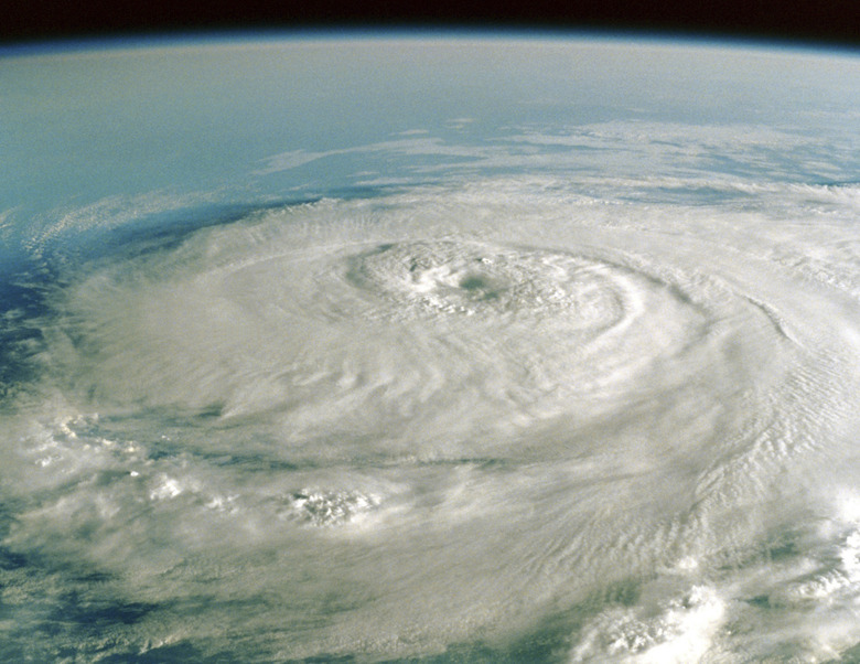
Looking down upon them from space, tropical storms look like a gigantic whirlpool of clouds. Tropical storms can reach up to 400 miles wide and up to five miles high. The calm eye of the storm measures between 20 and 40 miles wide.
Winds in the eye of the storm are calm, typically up to 15 miles per hour, and there is no rain here because cool air sinks in the eye. Hot winds spiral, rising around the eye to fuel the cyclone. The thick storm clouds that surround the eye of the storm are called the eyewall. Thunderstorms, heavy rain and the strongest winds occur in the eyewall.
Surrounding the eyewall are curved bands of clouds that spiral away called rainbands. These rainbands can produce heavy rain and strong winds. Sometimes, gaps between the rainbands leave areas within the storm with no rain or wind.
Tropical Storm Weakening
Tropical Storm Weakening
Several factors result in tropical storms weakening. When storms move into larger vertical wind speed environments, or areas with low sea temperatures, dry conditions or other changes in wind speeds, the storms can break up. Occasionally during strong tropical storms the rainbands form their own strong thunderstorms.
These intense rainbands move towards the eyewall and take on its moisture and momentum, ultimately weakening the entire cyclone or replacing the inner eyewall and enabling the storm to continue or become stronger.
Storm Size and Intensity
Storm Size and Intensity
Storm intensity is more destructive than storm size. The second most destructive cyclone in the United States was Hurricane Andrew in 1992. Hurricane Andrew was relatively small with rainbands reaching up to 100 miles from the eye. However, it was an intense category five hurricane with maximum sustained windspeeds of 141 miles per hour and gusts up to 169 miles per hour.
References
- SciJinks: How Does a Hurricane Form?
- BBC Bitesize GCSE: Tropical Storms
- National Weather Service: Tropical Cyclone Structure
- BBC Newsround: What's the Difference Between Hurricanes, Cyclones and Typhoons?
- Met Office: Development of Tropical Cyclones
- National Ocean Service: What Is the Difference Between a Hurricane and a Typhoon?
- Monthly Weather Review: Factors Affecting the Weakening Rate of Tropical Cyclones Over the Western North Pacific
- Unidata: Community Hurricane Preparedness
- National Parks Service: Hurricane Andrew (1992)
Cite This Article
MLA
Jerrett, Adrianne. "Stages Of A Tropical Cyclone" sciencing.com, https://www.sciencing.com/stages-tropical-cyclone-8709867/. 30 September 2021.
APA
Jerrett, Adrianne. (2021, September 30). Stages Of A Tropical Cyclone. sciencing.com. Retrieved from https://www.sciencing.com/stages-tropical-cyclone-8709867/
Chicago
Jerrett, Adrianne. Stages Of A Tropical Cyclone last modified March 24, 2022. https://www.sciencing.com/stages-tropical-cyclone-8709867/
