What Are The Three Landform Regions Of The Middle Atlantic States?
The landforms of New York, Pennsylvania, New Jersey, Maryland, Delaware, and Washington D.C. form a mosaic of mineral ridges, shale valleys, glacial and impact craters, sand dunes, tidal estuaries and river systems. Three land-form regions of the Middle Atlantic states are glacial plateaus and plains, coastal beaches with barrier islands and mountains. The Chesapeake Bay, Susquehanna, Potomac and James Rivers were formed by melting glaciers. Lush forests populated with diverse wildlife cover the wetlands.
Pennsylvania's Limestone Valley
Pennsylvania's Limestone Valley
Pennsylvania's Limestone Valley from the southern half of the Lehigh Valley to South Mountain exports limestone concrete, mortar and plaster used in tile, brick and paint. Sand and gravel left by pre-historic glaciers and flowing rivers formed mineral deposits and rock formations. In 2010, according to the United States Geological Survey (USGS), Pennsylvania produced minerals worth $6.25 billion. Limestone formations with minerals, crystals and fossils became tourist destinations. Lost River Caverns in the Lehigh Valley is open to tourists. Additionally, a field of boulders left by a glacier actually ring when they are struck with a hammer or another rock. During the Cambrian era, 505- to 570 million years ago, sand and gravel covered shells and invertebrates forming the Marcellus shale petroleum reservoir in southwestern Pennsylvania.
Chesapeake Bay
Chesapeake Bay
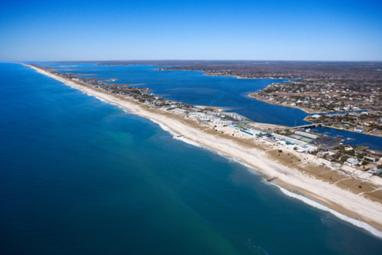
The Mid-Atlantic coastal landforms are characterized by barrier islands, linear barrier beaches and inlets. Glacial bluffs form a section of the Long Island beach. Waves shape and change the long linear barrier beaches of the barrier islands, which form natural channels of mixed energy. Beach erosion is greater on the seaward side, and sediment is deposited at the end of the channel leaving the barrier island wider at the end of the channel. Mid-Atlantic mainland beaches are characterized by dunes and extensive wetlands, marshes and swamps. The Chesapeake Bay is the largest estuary in the United States with tributary rivers, which flood at high tide. Sediment is deposited and accumulates at the mouths of rivers developing marshes and swamps.
New Jersey, Maryland, Delaware Wetlands
New Jersey, Maryland, Delaware Wetlands
Tidal freshwater and saltwater marshes are flooded twice daily by the Atlantic Ocean tides. Tidal saltwater marshes and swamps border the Atlantic Ocean. Salinity increases with proximity to the Atlantic Ocean. Tidal freshwater marshes and swamps line the upper sections of the tidal rivers. Peat basins support lush forested seepage wetlands, which cover clay or rock that surface water can not penetrate. Diffuse surface water rivulets, or streams never dry, and the soil stays saturated. Wetland forests are dense with shrubs, ferns, swamp oak, willow, chestnut, green ash, red maple, and black gum tees growing in standing water that does not drain. White-tailed deer, squirrels, red and gray foxes, raccoons, opossum, skunk, mallards, wood ducks, crows, and snapping turtle populate the swamps.
Allegheny or Pocono Mountains
Allegheny or Pocono Mountains
The Allegheny or Pocono Mountains are broad, rounded ridges separated by broad valleys. Skiing is possible in the Pocono Mountains. The Allegheny resistant rock ridges cover seven Pennsylvania counties. The Appalachian Mountains have eroded into soft ridges. The highest elevation in Pennsylvania, Mt. Davis, is 3,213 feet high. The Glaciated Pocono Plateau is a broad steep to moderately steep slope of erosion resistant flat sandstone. Elevations range from 1,200 to 2,320 feet. Weather can be severe. Water drains only from small streams, and the rock surface is smooth. Glacial deposits are visible on sandstone boulders. Swamps and peat bogs in depressions created by glaciers support shrubs and trees.
References
- United States Geological Survey: Landforms of New England and Mid-Atlantic Beaches
- United States National Park Service: PaleoIndian Life in the Chesapeake Bay Region
- United States Geological Survey: Marcellus Shale – Appalachian Basin
- Pennsylvania Department of Environmental Protection: Noncoal Mines and Quarries In Pennsylvania
Cite This Article
MLA
, Pat Martin. "What Are The Three Landform Regions Of The Middle Atlantic States?" sciencing.com, https://www.sciencing.com/three-regions-middle-atlantic-states-8250156/. 24 April 2017.
APA
, Pat Martin. (2017, April 24). What Are The Three Landform Regions Of The Middle Atlantic States?. sciencing.com. Retrieved from https://www.sciencing.com/three-regions-middle-atlantic-states-8250156/
Chicago
, Pat Martin. What Are The Three Landform Regions Of The Middle Atlantic States? last modified March 24, 2022. https://www.sciencing.com/three-regions-middle-atlantic-states-8250156/
