Warning Signs Of Storms
For as many balmy, sun-splashed days as it serves up, the atmosphere can also turn belligerent and downright dangerous. From a roaring midwinter blizzard to the seawater-fueled maelstrom of a hurricane, storms are among the planet's most awesome phenomena. Closely monitoring forecasts and heeding any and all storm warnings is the most effective way to stay weather-safe, but you may supplement your meteorological awareness with in-the-field observations of incipient atmospheric disturbances.
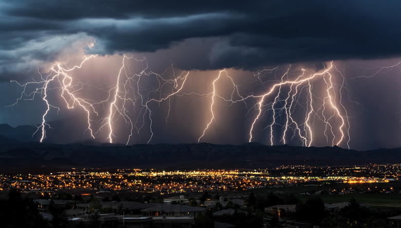
Dodging Thunderstorms
Dodging Thunderstorms
Thunderstorms stem from cumulonimbus clouds, created when atmospheric instability — as conjured by intense heating or the fronts marking the boundaries of two air masses — allows for a cumulus cloud's rapid vertical growth. Fleets of puffy cumulus are often rightly called "fairweather" clouds, but if they appear early enough in the day, they may indicate an atmosphere unstable enough to produce cumulonimbus by the afternoon. You can I.D. a thunderhead-in-the-making by surging cloud towers — representing fast-rising air parcels — lifting the summit of a cumulus. Lightning becomes a risk as soon as you see precipitation falling from the cloud base — including "fallstreak" curtains of virga, which is rain that evaporates before it reaches the ground — and as the thunderhead takes on a wispier, more blurred look, which indicates the formation of ice particles. Recognize the downdrafts of fast-approaching storms as gusty, shifting winds redolent of ozone. Keep an eye out for a mature cumulonimbus's anvil-shaped crown, the underside of which may be pouched with arresting mammatus bulges.
The Fiercest Storms: Tornadoes
The Fiercest Storms: Tornadoes
Meteorologists still don't fully understand the mechanisms by which tornadoes — the Earth's most violent storms — spark, but most dangerous "twisters" arise from exceptionally powerful thunderstorms. Watch for cumulonimbus sporting "overshooting tops," where cloud turrets rise above the flat-topped anvil: they may have the intensity to spawn a tornado. The rotating thunderstorms called supercells sometimes drop spiraling wall clouds from their base, formations that may evolve into funnel clouds that become tornadoes if they touch down. The appearance of a bright-lit "clear slot" near a wall cloud, created by a strong thunderstorm downdraft, sometimes immediately precedes a tornado's creation. Keep in mind such field marks may be obscured by intervening scud clouds or rain.
Ocean Howlers: Hurricanes
Ocean Howlers: Hurricanes
Hurricanes — also called tropical cyclones or typhoons — are gargantuan storms of immense destructive power, and you should never rely on field meteorology to stay out of harm's way. Besides, given its vast horizontal and vertical dimensions and the swirling cape of clouds that attends it, it's hard to distinguish the leading edge of a hurricane from that of a garden-variety warm front. That said, the National Oceanic and Atmospheric Administration's Hurricane Research Division offers some on-the-ground clues for a Category 2 storm. Several days ahead of hurricane landfall, a coastal observer might see innocuous cumulus yield to clear, sunny skies, but regular incoming swells, increasing in height and frequency, forebode the distant tempest. By roughly 36 hours ahead of landfall, a cirrus shelf may appear on the ocean skyline, eventually spreading into a high overcast. With the barometer dropping 0.1 to 0.2 millibars per hour and quickening wind forming whitecaps, the 24-hour period before the full storm hits sees fast-moving scuds beneath the dark overcast and gusts strengthening rapidly. A Category 2 hurricane in full force will have wind speeds of 96-110 mph.
The Whiteout: Blizzards
The Whiteout: Blizzards
The National Weather Service's criteria for a blizzard include winds or frequent gusts of 56 kilometers per hour (35 miles per hour) or more; visibility of a quarter of a mile or less; and a forecast projecting these conditions to continue for at least three hours. Such an event need not involve any falling snow; high winds alone can whip up terrestrial snow into a whiteout ground blizzard. In winter, the front of an extratropical cyclone — main weather-maker for the middle latitudes — can provoke blizzards, as in the East Coast's notorious Nor'easters. Such a low-pressure system may first announce itself with scattered cirrus thickening into cirrostratus, an overcast that deepens with incoming low clouds that herald precipitation. When a cold air mass passes over a large reach of open water, lake-effect snow may form leeward blizzards. Just ahead of such a situation, a downwind observer on a lake or seashore may see a bank of towering cumulus out over the water.
References
- National Weather Service: JetStream: Lightning — Frequently Asked Questions
- National Weather Service: JetStream: The Necessary Ingredients for Thunderstorms
- Mountain Thunderstorms: Their Formations and Some Field-Forecasting Guidelines; Jim Bishop
- National Weather Service: Spotter Reference Guide
- National Oceanic and Atmospheric Administration: Hurricane Research Division — Frequently Asked Questions (H5)
- Firefly Guide to Weather Forecasting; Storm Dunlop
- University of Wisconsin-Madison: Cooperative Institute for Meteorological Satellite Studies — Lake Effect Snow Band Brings Heavy Snow to Pennsylvania
Cite This Article
MLA
Shaw, Ethan. "Warning Signs Of Storms" sciencing.com, https://www.sciencing.com/warning-signs-storms-7568556/. 24 April 2017.
APA
Shaw, Ethan. (2017, April 24). Warning Signs Of Storms. sciencing.com. Retrieved from https://www.sciencing.com/warning-signs-storms-7568556/
Chicago
Shaw, Ethan. Warning Signs Of Storms last modified March 24, 2022. https://www.sciencing.com/warning-signs-storms-7568556/